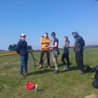
Aparatura do pomiarów konduktometrycznych CMD Explorer i CMD Mini Explorer
Aparatury CMD Explorer i CMD Mini Explorer to nowoczesne systemy pomiarowe charakteryzuje się dużą rozdzielczością zarówno pionową jak i poziomą dla ośrodków dobrze przewodzących. Aparatury uzupełniają się co do zasięgów głębokościowych, a pomiar odbywa się w sumie na sześciu poziomach głębokościowych dla każdej z dwóch konfiguracji układu pomiarowego tj. HD i VD. Pozwala to na interpretację geofizyczną i uzyskanie przedziału głębokościowego od ok. 0.25 m do ok. 7 m. Aparatury wykorzystują metodę konduktometryczną która należy do metody indukcyjnej opartej o prawo indukcji Faradaya. Metoda umożliwia dobre rozpoznanie płytko zalegających dobrze przewodzących warstw geologicznych. Pozwala ona na obrazowanie ośrodka geologicznego tj. określenia rozkładu przewodności będącej rezultatem interpretacji geofizycznej. W metodzie tej brak jest problemu uziemienia bo pole wzbudzane jest indukcyjnie a nie galwanicznie. Pomiar w metodzie konduktometrycznej można wykonać szybko na dużym obszarze i może go wykonać jedna osoba.
Udostępnienie aparatury wymaga zgody kierownika katedry. Udostępnianie odbywa się na zasadzie współpracy lub odpłatnie, w ramach zleceń komercyjnych.
- pomiary inżynieryjne w budownictwie drogowym i kolejowym
- lokalizacja stref wodonośnych i osuwisk, stref wycieku wody np. na wałach przeciwpowodziowych czy w podłożu wałów
- monitorowanie wycieków ścieków
- mapowanie geologiczne
- w rolnictwie monitorowanie jakości gleby
- w archeologii
- środowiskowe mapowanie aureoli zanieczyszczeń
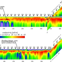
Aparatura pozwala na pomiar przewodności pozornej dla sześciu poziomów głębokościowych dla dwóch konfiguracji HD i VD różniących się rozdzielczością i zasięgiem głębokościowym. Aparatury CMD Explorer i CMD Mini Explorer uzupełniają się głębokościowo (każda po trzy poziomy dla dwóch konfiguracji). Długość profilu jest dowolna a krok pomiarowy wynosi standardowo 1 m umożliwia uzyskanie dobrej rozdzielczości poziomej.
Jednostka odpowiedzialna
Grupa / laboratorium / zespół
Laboratoria metod geofizycznych / Laboratorium mobilne / Laboratorium Badań Geoelektrycznych